11 Monitoring And Management
11.1 Introduction
The goal of roadside revegetation is to establish healthy, functional communities of native plants along roadsides and on road-related disturbances. However, projects to establish native plants on disturbed sites rarely turn out exactly the way they were planned. Therefore, regular visits to the project to evaluate progress, and to intervene if necessary, are essential parts of the revegetation process.
Monitoring is carried out for two reasons: 1) to correct, manage, and maintain the project effectively, and 2) to learn lessons for future projects. Monitoring provides the answers to the following questions:
- Is native vegetation establishing well, or is some corrective action needed?
- Were regulatory standards or revegetation commitments met?
- Were there differences in plant responses between different revegetation treatments?
These questions may be answered simply through general observations during routine field visits, through formal photo point monitoring, or through statistical methods. Monitoring begins during the implementation phase and continues after the project has been installed. A general monitoring protocol that can be applied to all revegetation projects does not exist. Instead, monitoring should be tailored to the objectives of each project and to the uniqueness of the site. It is important to determine in advance whether formal data collection and statistical analysis is necessary for the project. Simple field visits or photo point monitoring may provide sufficient information to determine whether objectives have been met. This chapter discusses general monitoring and management steps. If statistical methods will be necessary, Chapter 12 outlines some statistical monitoring protocols that cover the most common roadside revegetation objectives and conditions.
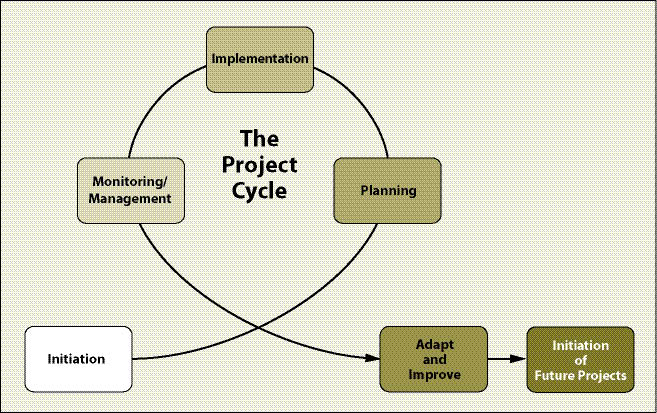
Information collected during monitoring will guide management and maintenance activities for the current project. This information can also be used to improve revegetation techniques for future projects. Monitoring completes the project cycle by providing feedback regarding the success or failure of a revegetation project. This information is used to adapt and improve other projects that are in the initiation, planning, or even implementation phases of the other project cycles (Figure 11.1).
Monitoring can also play an important role in advancing the knowledge and understanding of establishing native plants on highly disturbed sites. This relatively new field of study lacks basic field-tested techniques. With well-designed monitoring projects, the revegetation specialist can provide valuable information for the use of native plants in revegetating harsh sites.
The monitoring and management phase of the project involves several steps:
- Revisit project objectives and DFCs,
- Develop monitoring strategy and protocol(s),
- Record data and observations,
- Evaluate data and apply any corrective measures,
- Organize and file project results, and
- Share lessons learned.
Monitoring information is utilized to evaluate progress and to inform any management activities needed to correct the results. Long-term road maintenance and management is usually the responsibility of the road-owning agency. However, monitoring information can facilitate long-term results and help inform management even after the revegetation specialist's role is completed.
11.2 Revisit Project Objectives and DFCs
A common pitfall in many monitoring projects is the lack of clearly stated objectives or reasoning behind data collection. A good monitoring project is not defined by the amount of data collected, but by whether the data adequately and efficiently determines whether the objectives of the revegetation project were met. This question can only be addressed when the objectives for monitoring are clearly stated. Monitoring efforts must not only link back to the original project objectives, but also to the specific DFCs developed in the planning phase (See Chapter 4). Objectives and DFCs set the standards (sometimes called "performance standards," "thresholds," or "indicators") against which the project is evaluated (Clewell 2004).
DFCs are often stated in quantitative language. For example, the DFC for a cut slope three years after construction is stated in the revegetation plan as "less than 25% bare soil will be exposed" and "vegetative cover will be composed of greater than 70% native species." These DFCs are very specific and can be used as target values, or thresholds, for determining whether or not the project was successful. Monitoring methods, or protocols, are developed specifically around each of these targets or thresholds. When monitoring is approached in this manner, only the information needed to determine whether targets were met is collected. Expensive, superfluous data collection is avoided because the DFCs were clearly defined.
11.3 Develop Monitoring Strategy and Protocol(s)
The DFCs identify what will be monitored and defines the minimum acceptable thresholds. The monitoring strategy defines how those criteria will be measured and evaluated. This involves issues of scope (what level of detail or certainty is needed?), methods (what is the best way to obtain the necessary information?), and location, timing, and frequency (where, when, and how often should monitoring take place?). After the information is collected, the DFC threshold values will be used to evaluate success or failure, in order to determine if results are acceptable or if corrective action is required.
A monitoring protocol is a specific set of directions that outlines, step by step, how the monitoring will actually take place in the field. Sometimes several different protocols will be utilized on one project. The monitoring strategy sums up the monitoring protocols and creates a comprehensive map, schedule, and budget for monitoring activities for the project.
11.3.1 Define Scope
Scope defines the level of monitoring detail. Some portions of the revegetation project might require only a project diary and a series of photographs while other areas within the project will require a statistically designed monitoring protocol. At a minimum, most projects require annual visits and recorded observations or qualitative assessments. Portions of revegetation projects may require statistically-based monitoring to ensure regulatory compliance and accountability. For example, if water quality standards dictate that road sections near a high-value fishery have no greater than 20% bare soil the first year after construction for sediment control, the importance of this project to fisheries and water quality will require high confidence in the accuracy of the data. This might require more intensive data collection and statistical analysis to ensure a higher level of certainty. On the other hand, road sections that do not affect the stream system would have less need to collect data for statistical analysis of this intensity. In such cases, qualitative assessments such as photo point monitoring or fewer sampling points may suffice (Inset 11.1). In general, the scope of monitoring should reflect the importance of the revegetation objective and the ecological sensitivity of the project site and surrounding areas (See Chapter 12).
11.3.2 Determine Location, Timing, and Frequency
Choosing appropriate sampling areas to assess whether project objectives were met is a foundation of a good monitoring strategy. Some revegetation projects can be complex and cover many acres. For these projects, it is important to identify specific monitoring areas. However, not every area needs to be monitored. The revegetation unit is usually the basic unit of sampling. There should be little reason to split out the revegetation units in order to determine whether standards or thresholds were met. Finer delineation of areas within revegetation units for monitoring should only be done if there are specific questions to answer about treatment effectiveness or differences.
Determining the most appropriate time of the year and frequency for monitoring is a key part of developing a monitoring strategy. Some portions of a revegetation project may require only one monitoring visit, which may simply be carried out as part of quality control during the implementation phase (See Chapter 9). For example, if a two-inch application of composted mulch is a stated objective in the revegetation plan, then one visit to the site, preferably during mulch application, will suffice to confirm whether this occurred or not. For other objectives, a series of observations over time will be necessary. For example, a planting contract requires 400 live trees to be established the first year after planting and 300 live trees by the third year. This project would need to be monitored twice, once at the end of the first year and once in the fall of the third year.
It is important to define the season that monitoring will take place because vegetation changes from season to season. This will affect the results of the data being collected. For instance, if the monitoring objective is to determine the species cover after seeding native grasses and forbs, monitoring should take place in the early summer when plants are flowering and species are easily identifiable. Collecting soil cover data, on the other hand, is often done in the fall prior to winter rainstorms, since the revegetation specialist will want to know the amount of ground cover that will be protecting the soil during these events. Monitoring first year seedling survival should be done in fall and not in spring or summer. Taking data in spring or summer will show higher survival; by fall, most of the seedling mortality will have occurred.
11.3.3 Develop Sampling Methods
Sampling methods define what parameters will be measured and how the data will be collected. Parameters may be biotic or abiotic, and are determined by the revegetation objectives. For example, vegetative cover can be measured as basal cover or aerial cover. If the objective is erosion control, then basal area is usually measured. If the revegetation objective is visual aesthetics, then aerial cover would be selected. In another example, if a revegetation objective is to reestablish a working group of species, then measuring for species presence would be conducted. If this is the case, the interest is only in working group species, so only these species need to be monitored. Any other species can be grouped into broader categories, such as grasses and forbs, for measurement. This strategy reduces the need to identify all species present in a sampling unit, and instead focuses data collection on the key species or groups of species that are relevant for meeting project objectives.
11.3.4 Summarize Monitoring Strategy
The monitoring protocol or protocol(s) to be utilized to evaluate the progress should be summarized into an overall monitoring strategy (Table 11.1). The monitoring strategy should have these components (Elzinga and others 1998):
- Summary of objectives. The purpose for monitoring, the project objectives and DFCs to be met, DFC "threshold values" for success or failure on each revegetation unit.
- Monitoring area map. The monitoring area map locates and identifies all monitoring areas in the road project area. For example, the monitoring areas identified in Table 11.1 would each be located on a road map.
- Summary of monitoring protocols. The strategy summarizes the general type of monitoring, including scope, location, timing, frequency, and sampling methods for monitoring each revegetation unit (Table 11.1).
- Consolidated timelines. A comprehensive timeline should be developed for the entire project, detail the schedule for how each revegetation area will be monitored, and include the due date for the Final Monitoring Report.
- Expertise. Some monitoring protocols will require specific expertise in botany, soils, or other natural resource disciplines. This should be addressed in the strategy to make sure these resources are available.
- Costs. A general estimation of costs can be made once the monitoring protocols have been selected. It is important to take stock of the budget at this point since this is the final phase of the revegetation project and there must be enough funding to implement the monitoring.
- Monitoring oversight. One person must have oversight of all monitoring activities; it is the responsibility of this person to ensure that the protocols are being implemented within the timelines that were developed. This person completes the final monitoring report and summarizes important findings.
Table 11.1 — Example of a basic monitoring summary. This table, accompanied by a map of the revegetation project, are the basic elements of a monitoring strategy. |
||||
Revegetation Unit |
DFCs or Objective |
Monitoring Protocol |
Year |
Expertise Required |
1 Steep Cut Slope |
- |
Photo point |
0, 1, 3, 5 |
- |
70% soil cover |
Soil cover |
1 |
- |
|
90% soil cover |
Soil cover |
3 |
- |
|
60% native vegetation |
Species presence |
3 |
Botany |
|
Nitrogen analysis |
Soil samples |
2 |
Soils |
|
2 Obliterated Road |
- |
Photo point |
0, 1, 3, 5 |
- |
400 live trees per acre |
Plant survival |
1 |
- |
|
300 live trees per acre |
Plant survival |
3 |
- |
|
4 foot average tree height |
Plant growth |
3 |
- |
|
3 Wetland |
- |
Photo point |
0, 1, 3, 5 |
- |
80% survival of plants |
Plant survival |
1, 3 |
- |
|
70% native plant cover |
Species cover |
3 |
Botany |
|
No invasive plants |
Invasive plant survey |
1, 3 |
Botany |
|
11.4 Record Data and Observations
With the monitoring protocols defined and the overall strategy in place, data and observations can be recorded as schedules. Methods of data collection can be qualitative or quantitative, complex or simple. No matter what methods are to be utilized, clear written instructions in the protocols will outline exactly how data is to be collected. Chapter 12 illustrates the most common statistically-based monitoring protocols needed to meet most roadside monitoring objectives. The protocols must still be used in the context of the unique environmental and operational characteristics of the revegetation unit. For example, accessibility to a cut slope for monitoring soil cover might be limited due to very steep slope gradients. Although the soil cover monitoring protocol would be selected, modifications would be necessary to assure personnel safety. The modified protocol would not be the same as one developed for areas where slope gradients are gentle. Keep good records of the information that is collected. A field monitoring form (such as the example provided in Table 11.2) is a useful tool to keep information organized and consistent as measurements are taken over time.
11.5 Evaluate Data and Apply Any Corrective Measures
There is no purpose in monitoring if the information will not be appropriately analyzed. The primary reasons monitoring data is not analyzed may include: 1) the monitoring plan was too complicated (massive amounts of data were generated); 2) insufficient thought was given to analytic methods; 3) monitoring was not designed in a meaningful or statistical manner; or 4) the monitoring objectives were poorly stated. Chapter 12 addresses these issues and presents strategies to streamline monitoring so that only essential information is collected and data can be quickly and easily analyzed.
Analysis of the monitoring data provides the feedback needed to identify and correct problems as they arise (Figure 11.1). There are many reasons corrective actions may be necessary as the project develops. This may include unanticipated events, such as unforeseen invasion/infestation of weeds or other pests, theft or human impacts, or unforeseen weather events, such as drought or early frost. In addition, there may have been some erroneous assumptions during the planning phase about either the appropriate future conditions for the site, or about the appropriate method to achieve the desired conditions. The sooner issues can be identified through data collection and analysis, the sooner (and more economically) they can be corrected. This is the basis of good management.
Table 11.2 — Example Field Monitoring Form (adapted from Elzinga and others 1998). |
Project name: |
Dates of data collection: |
Personnel: |
Location of monitoring (attach map and GPS coordinates): |
Revegetation unit: |
Revegetation treatments: |
Desired future conditions (DFCs): |
Sampling objectives: |
Monitoring protocol (soil cover, species presence, species cover, etc.): |
Sampling design (size and shape of sampling unit): |
Number of transects or quadrats: |
Type of data analysis: |
Description of codes (on map or in notes): |
Notes and location of accompanying map and data files: |
11.6 Organize, File and Report Project Results
Monitoring is a long-term effort that can span many years. It is important to document, organize, and file monitoring information in a manner that will be understandable to others years later. The cover sheet illustrated in Table 11.2 is useful to attach to the front of a monitoring data set when filing. It details the date, location, and methods of monitoring.
Be sure that the project records include:
- The diary or log kept during the project,
- Copies of all maps and plans,
- Copies of all budgets and task orders,
- Photos and data, and
- Reports and evaluations.
Depending on the complexity of the project and the agencies involved, some reporting of monitoring results will be necessary. Reports are an excellent opportunity to summarize the information collected and describe any management actions taken to correct shortcomings.
Timing varies, but typically, a Final Monitoring Report is submitted after the third monitoring season. This report summarizes whether the revegetation project met standards and commitments made during the planning stages. It is important to review the original revegetation plan to address whether the desired future condition was fulfilled as stated. The report should address this in the context of successes or failures in each revegetation unit.
11.7 Share Lessons Learned
Revegetating highly disturbed sites with native plants is a relatively new field of study. Well-designed and analyzed monitoring projects can provide good information to a wider audience of practitioners and scientists working in this field. By taking the time to share monitoring results, the science and practice of revegetating highly disturbed sites can be advanced.
Conferences, societies, newsletters, internet sites, and trade publications are some venues to share knowledge. The small-scale trials that were carried out to test, for example, different rates of fertilizer, tackifier, seeds, or hydromulch should also be of great interest. Case histories or trials can be shared on websites, in journals, or in posters and presentations at conferences (SER 2005). Evaluations of the overall approach taken and the lessons learned will be an important contribution to future projects.
11.8 Roadside Maintenance and Management
Following road construction, maintenance of roadside revegetation is usually administered by local agencies. Once the final revegetation report is submitted and the reimbursable agreement is closed, maintenance and monitoring of vegetation is no longer the responsibility of the revegetation specialist. However, coordination with the road maintenance agency is vital to ensure the long-term success of the project. Monitoring information can help guide effective decision-making for the life of the project site. While specific maintenance strategies are beyond the scope of this manual, many resources exist to protect and enhance native vegetation on roadsides and to reduce the spread of invasive species. For example, on a national level, guidelines have been developed for Integrated Roadside Vegetation Management (IRVM) to maintain healthy populations of native plant communities to exclude invasive species (Berger 2005). Many road-owning agencies have their own protocols for monitoring and managing roadsides. Readers are encouraged to explore these resources in order to support the goal of healthy native plant communities on roadsides.
11.9 Conclusion
Roadside revegetation is an integrative process that involves careful planning, implementation, and monitoring. It is important to select monitoring strategies that generate useful information targeted to project objectives and DFCs. Analyzing and sharing results is a key practice to guide effective management of the project, as well as to improve results on future projects.