8 Revegetation Plan Example
Sunriver To Mt. Bachelor
Draft Revegetation Plan
 March 2006
OR PFH 244-1(1)
Deschutes National Forest
Deschutes County
Oregon
Background
This revegetation plan outlines the basic actions that will be taken by the USDA Forest Service in association with Western Federal Lands Highways Division (WFLHD) of the Federal Highway Administration (FHWA) to revegetate the Sunriver to Mt. Bachelor Highway project [OR PFH 244-1(1)]. Construction is scheduled to begin in spring 2006, with revegetation implementation to begin in fall 2006.
The Sunriver to Mt. Bachelor project is located entirely on the Bend/Fort Rock Ranger District, Deschutes National Forest in Central Oregon.
Roles, Responsibilities, and Contacts
The entire project is bordered by National Forest lands. The environmental specialist will be the main contact during the planning phase. During construction, the project engineer will be the main contact. After the project has been completed, the county engineer and environmental specialist will be the contacts.The project as planned (see Sunriver to Mt. Bachelor Highway Environmental Assessment) will minimally affect soil conditions along the roadway. Cuts and fills will be designed to minimize erosion. The erosion and sediment control plans will be developed by the WFLHD and will be the responsibility of the contractor. The Forest Service will have a limited role, primarily in providing guidance for temporary stabilization practices. Key to this guidance will be the selection of appropriate materials and methods that will not deter future revegetation efforts.
Revegetation Objectives
The following revegetation objectives were addressed in the Environmental Analysis (EA) for cuts, fills, and abandoned roads:
- Enhance scenic beauty using native grass, forb, shrub, and tree species;
- Control noxious weeds using only EA approved herbicides and native grass and forb species;
- Maintain slope stability using native grass, forb, and shrub species;
- Minimize soil erosion with native grass, forb, shrub, and tree species; and
- Maintain biodiversity of the surrounding plant communities by planting locally adapted native species.
Contact |
Organization |
Phone |
Role |
|
Jim Scott |
USDA Forest Service |
FS Agreement Liaison |
||
April Jones |
USDA Forest Service |
Lead Revegetation Specialist |
||
Jill Smith |
USDA Forest Service |
Revegetation Specialist |
||
Adam Riles |
Deschutes National Forest |
Local FS Liaison and Permitting Specialist (Bend/Fort Rock District) |
||
Carlos Escobar |
FHWA |
Project manager — general FHWA project oversight. |
||
Lindsey Chen |
FHWA |
Project Engineer |
||
Sam James |
FHWA |
Design Engineer |
||
Philip West |
FHWA |
Environmental Specialist — agreement coordinator, main contact between FHWA and other regulatory agencies, including DEQ and EPA |
||
Carol Clint |
Deschutes County — Director of Public Works |
|||
The revegetation objectives for the source and waste areas are for suitable native grass and forb vegetation for erosion control and wildlife forage.
Project Constraints
The following are the major anticipated constraints to successful revegetation:
- Limited topsoil;
- Wind at higher elevations;
- Frost pockets;
- Hot, dry south slopes in summer;
- Animal damage — gophers and deer;
- Noxious weeds — spotted knapweed (Centaurea maculosa);
- Non-native invasive species — mullein (Verbascum thapsus);
- Threatened and endangered plants — greentinge Indian paintbrush (Castilleja chlorotica);
- Covering of plants with gravel applied to roads in winter;
- Herbicides — limited chemicals and NEPA cleared sites;
- Oversteepened slope gradients;
- Snow damage from plowing/blowing accumulation;
- Winter desiccation; and
- Driving on obliterated roads.
Laws, Regulations and Policies
Following Forest Service National Policy, only genetically appropriate, locally adapted native plant materials will be used in the revegetation of this project.
Laws governing surface water quality are not major constraints on this project, since there are no perennial or intermittent streams, lakes, or wetland areas within the project area or adjacent areas.
Noxious Weeds
Prevention
As stated in the EA, the contractor will be required to clean all equipment and vehicles before entering and leaving National Forest lands to minimize spread of state- and county-listed noxious and non-native plants. Mud, dirt, and plant parts will be removed from project equipment before moving equipment into project areas. Also, the contractor will be required to use gravel from a known weed-free site. Both Deschutes Bridge and Dutchman Pits were found by Forest Service personnel to be free of noxious weeds. Any other potential sources will have noxious weed surveys completed before being used. The contractor will be responsible for environmental clearance on other potential sites. The contractor will be required to monitor and flag the known knapweed sites, and remove any plants before project work begins. The Forest Service has record of known knapweed sites and will supply this information to the contractor. The contractor will be required to use weed-free staging areas. Vehicles or heavy equipment will not be allowed to park, or be staged at the junction of FS Roads 40 and 41, or at the junction of FS Road 45 and Oregon Highway 372, where there are known noxious weed sites.
Control
Monitoring and treatment of noxious weeds and invasive plants will occur regularly beginning in 2004 and will continue through successful vegetation establishment. The monitoring and treatment plan will be cooperatively developed by WFLHD, FS, and County staff with the FS as lead agency. The plan is not a substitute for prevention, but rather directs and funds additional resources to monitor and treat noxious weeds and invasive plant species in, and adjacent to, the construction corridor during and after project implementation. Monitoring also includes haul roads and source and waste areas.
Proposed Revegetation Schedule
Plant Materials
Locally-collected plant materials will be obtained under the guidance of the Forest Service district botanist through seed collection contracts. Seed increase will be accomplished over a 3- to 4-year period using the regional seed increase contract. The following table gives a general schedule and rough estimate of cost of plant production.
Overall Monitoring
Monitoring will be conducted during late spring to early summer of the field season following the initial seed application. Areas of unsatisfactory plant establishment will be evaluated for retreatment and will be re-seeded, if appropriate, the following fall. Shrubs and trees will be assessed for establishment rate, survival, animal damage and need for protection, and potential need for replacement with new plants. Monitoring will continue over a period of 3 years to evaluate success in establishment, species composition, and percentage of plant cover. Noxious weeds will also be monitored for a minimum of 3 years, and will be eradicated if found on the site. "Soil cover" and "species presence" monitoring protocols will be used.
Revegetation Units
Five revegetation units plus source and waste areas were delineated for this project based on vegetation and soil field surveys. Subunits within 4 of the 5 units were delineated based on special treatment needs. The revegetation plan was developed based on existing disturbed, disturbed and recovered, and undisturbed reference sites for plant communities.
Climate
The project crosses through several distinct climate zones, often defined by distinct plant communities:
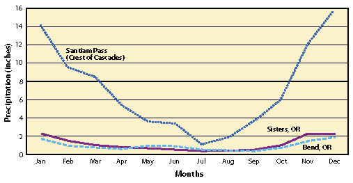
Lower Elevations (Revegetation Units 1, 2, 3). The beginning of the project (1,290 to 1,440 m [4,235 to 4,730 ft] elevation) has a climate similar to the towns of Bend or Sisters. The data collected at the weather stations in these towns show scant precipitation distributed relatively evenly throughout the year (Figure 8.1) with total annual rainfall between 12 and 14 in (30.5 and 35.5 cm). Typically, the melting snowpack recharges the soil profile in the spring; once plants become active, this moisture can become depleted quickly. Soil moisture is a limiting factor and seedling establishment should be approached with several objectives: 1) minimize soil moisture losses from evaporation by using surface mulch where possible; 2) keep competing vegetation away from planted seedlings by using surface mulch; 3) use deep-rooted, large container stock; 4) utilize two potential planting windows — in the fall after significant rains, or in the spring immediately after snowmelt and the soils are thawed. (Do not wait for higher soil temperatures.)
Snowpack is often gone by late winter. Frozen soils can extend into early spring. Soils must not be frozen when seedlings are planted.
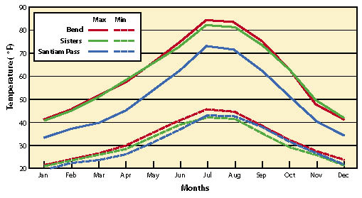
The lower elevations have distinctly warmer daily temperatures than higher elevations; minimum daily temperatures are very similar (Figure 8.2). Microclimates created by landforms can make some portions of the lower elevations as cold as, or colder than, the higher elevations. Revegetation Unit 2, for example, sits on a flat with poor air flow. Cold area settles into this area creating an inversion or frost pocket. Where lodgepole pine is the dominant or only tree species present in an area, it is often an indicator that the site is very cold. In areas where the road traverses cinder cones or on gently sloping terrain, the air flow is greater, and minimum air temperatures are not as cold, nor is duration as long.
Lack of a continuous snowpack and the very cold temperatures on some sites can create problems for fall-planted trees. Trees that are planted in the fall will be subjected to extremely cold temperatures if they are not covered by snow. This can be a problem with newly planted seedlings, especially during periods where soils are frozen and desiccating winds are high. Therefore, seedlings should be planted in late winter and early spring on these sites. Seeds can be sown either in the fall or early spring. If the seeds are sown in the early spring, they should be stratified for the required period before sowing and covered with a seedbed mulch or soil.
| Figure 8.1 — Precipitation for areas surrounding revegetation sites. |
 |
| Figure 8.2 — Minimum and maximum temperatures for areas surrounding revegetation sites. |
 |
Higher Elevations (Revegetation Units 4 and 5). The revegetation units at the higher elevations (1,440 to 1,645 m [4,730 to 5,400 ft]) are greatly influenced by snowpacks. On typical years, snow has accumulated by November and can last into April or May. Snowpacks often insulate, or moderate, ground temperatures. Therefore seeds or seedlings placed in the fall can be protected from extreme temperatures and wind by a deep snowpack. Seeds that are sown in the fall and covered with a snowpack are protected, stratified, and ready to germinate as soon as the snowpack has melted. If conditions are right, soils might not freeze under a snowpack and seedlings can grow roots during late winter to early spring (observed at Chiloquin Highway). The preferred period for sowing seeds and planting seedlings at these higher elevations is in fall.
At higher elevations, high winds can restrict plant establishment, especially in Revegetation Unit 5. Without protection, tree establishment may be difficult. Planting seedlings behind down, woody material such as logs can help protect seedlings during establishment. Using tree shelters can also protect the seedlings from wind desiccation and should be considered on these sites.
Extreme surface temperatures are encountered on south slopes, especially in the spring. Temperature readings from iButton® data loggers (Maxim Integrated Products, Sunnyvale, CA) placed near the intersection of FS roads 45 and 46 showed daily temperatures close to 100 °F (38 °C). High temperatures can create very harsh conditions for seed germination. On these sites, mulch should be considered. Shredded wood fibers will have stability on south slopes and create favorable conditions for seed germination.
On steep north slopes, soils thaw much later than south slopes. Soil moisture is maintained longer on north slopes, so soils are more prone to the effects of freeze-thaw cycles or frost heaving. On steep slopes, this can make the surface soil very unstable. Seeds that are in the process of germinating on these sites will move downslope. One option is the application of surface mulch that would stabilize the surface so seeds can germinate in a more stable seedbed.
Soils
Soils are derived from pumice parent material. These soils are unique in that they have low bulk densities, are single-grained, and have low cohesion. Since these soils are derived from recent volcanic activity, they are young with very little development. Nutrient levels are in the lower ranges for plants. In many areas, the soils are deep, equating to a high moisture supply for seedlings with deep roots.
Soil Nutrients: Table 8.4 shows four sites where topsoil will be removed, stored, and reapplied. Samples were taken uniformly from the 1 to 23 cm (0.4 to 9.0 in) surface horizon and represent a composite sample of soils. These results show the soils have low coarse fragment composition with loamy sand texture, a mildly acid pH (6.1 to 6.4), and low salt levels. Organic matter is between 3% and 4%, which is acceptable; total N is low for forest lands. Calcium and boron are low, and fertilizers or soil amendments containing these elements could be beneficial to plant growth. Soil testing should be done in reference areas and during construction to determine soil amendment rates.
Fertilizing: Commercially available fertilizers (nitrogen, potassium, and phosphorus) are unnecessary on abandoned road sites where trees are planted. Species such as lodgepole pine require very little nitrogen. On sites where mulch is being applied, nutrients should be available as the mulch decomposes. Application of mycorrhizal fungi, either at the nursery or in the planting hole, will assure that the seedlings are well colonized with appropriate beneficial fungi. This will help increase seedling access to soil water and nutrients. If seedlings show nutrient deficiencies at a later point in their development, fertilizers can be surface-applied around each seedling instead of broadcast.
For sites to be seeded, fertilizers can be beneficial. However, high applications of fast-release fertilizer in the first year (e.g., ammonium nitrate) can encourage the establishment of weedy or undesirable plants. Therefore, seeds should be sown in the first year without fertilizers and allowed to become established. Slow-release fertilizers can be applied in spring of the following year based on soil analysis. Products such as Biosol® and Fertile Fiber are good products to use. Since the disturbed sites on this project will be low in nitrogen, applying as much nitrogen by the second or third years, in this form, could be beneficial to establishing long-term native plant communities. Higher application rates of slow-release fertilizers are possible on the low elevation sites because lower precipitation presents less likelihood of deep leaching of nitrogen. Also, cold soil temperatures throughout much of the year mean the slow-release fertilizers will not decompose as fast and release nutrients. As the slow-release fertilizers break down, nutrients are taken up by the well-established native plants that convert the readily available nutrients into biomass, boosting nutrient cycling.
Topsoil Storage: It will be necessary to ensure that topsoil is free of seeds from undesirable vegetation. When possible, schedule work to accommodate the following:
- Topsoils are stockpiled when dry;
- Storage periods are kept to a minimum;
- Stockpiles are protected from becoming wet in the winter; and
- Weed establishment around stockpiles is avoided.
Covering the piles with plastic will help keep piles from becoming wet, and also prevent weed establishment. When reapplying topsoil, avoid mixing the topsoil with any of the subsoil material.
Revegetation Unit 1
Description — This unit is 2,600 m (8,535 ft) in length — between stations 0+200 and 2+810 and located from 1,290 to 1,320 m (4,235 to 4,340 ft) elevation on a south aspect. Vegetation consists of ponderosa (Pinus ponderosa) and lodgepole pine (P. contorta) with a bitterbrush (Purshia tridentata) understory. The main revegetation unit consists entirely of minor cut and fill slopes, where the cuts predominately have slopes of 1V:3H and the fills have slopes of 1V:4H. The cut and fill slopes total approximately 16,700 m2 (4.1 ac).
Site Limitations — Summer conditions are hot and dry, and evapotranspiration is high. The soil is loamy sand, which has low water-holding capacity, and can be hydrophobic in the summer. Gophers may be a problem.
Revegetation Objectives — Revegetation objectives are visual to blend with the surrounding forest stands and openings.
Treatments — This unit should become revegetated fairly quickly. A mix of species, including squirreltail (Elymus elymoides), western needlegrass (Achnatherum occidentale), Pacific lupine (Lupinus lepidus), silverleaf phacelia (Phacelia hastata), and rabbitbrush (Ericameria bloomeri) will be seeded. Scarlet gilia (Ipomopsis aggregata) and glaucous beardtongue (Penstemon euglaucus) may be added to the mix on the larger, more visible cut slopes. For gentle slopes (1V:5H or less), the seed mix will be applied with ground-based spreaders and covered with soil in late fall. The method to cover seeds will be determined later.
On all steep cut and fill slopes, hydroseeding (using the same seed mix) with 2,000 lb/ac mulch and tackifier will be applied in early fall.
This unit also contains 3 special subunits requiring additional treatments (Table 8.5).
Subunit 1.F.1. The majority of the fill will receive the same treatment as the overall Unit 1. The bottom of the fill, beginning 18 m (60 ft) from the road centerline, will be planted with Q-plug+1 ponderosa pine with a spacing of 3 x 3 m (10 x 10 ft) in a natural random pattern.
Subunit 1.A.1. This unit is a decommissioned road with only 1 entrance onto the main road. Once the road surface has been removed and subsoiled, planting islands will be established to blend with the surrounding forest type. Approximately 8 cm (3 in) of (contractor-supplied) mulch will be applied in 6 m (20 ft) diameter islands (approximately 14.5 m3 [19 yd3] of material per unit 1.A.1). Following mulch application, ponderosa pine will be planted into the established planting islands. The trees will be a combination of larger potted (4 l [1 gal]) trees at the entrance into the road, and smaller (Q-plug+1) trees throughout the rest of the unit.
Subunit 1.C.1. The majority of the cut will receive the same treatment as the overall Unit 1. Beginning 14 m (45 ft) from the road centerline, approximately 8 cm (3 in) of mulch will be applied to the cut slope (approximately 46 m3 [60 yd3] of material). Bitterbrush grown in D40 DeepotT containers will be out-planted into this area with a 3 x 3 m (10 x 10 ft) spacing (avoiding grid planting).
Desired Future Condition — Native grass and forb species will occupy 15% of ground cover 12 months after seeding and over 40% after the second year. NPDES permit requires establishment of plant ground cover of at least 70% of the surrounding natural vegetative cover.
Approximately 12 months following road decommission, the conifer seedlings will have been planted on the abandoned road area at a rate of approximately 445 trees/ac (1,100 trees/ha), with heavier concentrations at the beginning of the decommissioned road. At the end of 5 years, this area should have an overall tree stocking at a minimum 250 trees/ac (620 trees/ha).
Monitoring Protocol — Photopoint monitoring will be conducted in the fall of the first and third years following seeding throughout the main unit.
Survival on the planted subunits will be monitored within planting islands. Ten percent of planting islands will be monitored in the first, third, and fifth years.
Noxious weeds will be monitored for a minimum of 3 years and will be eradicated if found on the site.
Data Gaps — Do we need mulch to germinate and establish seedlings? Test in 2004 did not show a difference.
Does wood straw or shredded wood fiber increase surface moisture during germination, therefore increasing germination and establishment?
Does time of sowing make a difference in germination and establishment? Current practice is fall sowing. Would stratified seeds hydroseeded in spring establish as well or better than fall?
Revegetation Unit 2
Description — This unit is 7,400 m (24,280 ft) in length — between 2+800 and 10+200, and located from 1,320 to 1,365 m (4,340 to 4,480 ft) elevation on a mostly flat gradient. The vegetation consists of lodge-pole pine and small amounts of ponderosa pine, with bitterbrush and glaucus penstemon predominating in the understory. The stands are mixes of regeneration cuts, openings, and islands of dense lodgepole pine. The main revegetation unit consists of minor cut and fill slopes, where the cuts have slopes of 1V:2H to 1V:3H and the fills have slopes of 1V:4H. The cut and fill slopes total approximately 35,040 m2 (8.7 ac).
Site Limitations — The soil is loamy sand, which has low water-holding capacity and can be hydrophobic. Summer conditions are warm and dry. The unit has definite low-lying frost pockets. Gophers may be a minor problem.
Considering the high recreational use in this area, establishment of vegetation on the abandoned road areas may be difficult. Any forest opening on the Deschutes will become heavily used by off-highway vehicles (OHVs) and snowmobiles, which will impede survival and establishment of vegetation in these areas.
Revegetation Objectives — The Sunriver to Mt. Bachelor highway is used most heavily for recreational traffic during both the summer and winter seasons. Revegetation objectives are visual — that is, to maintain a grass and forb community to blend with the surrounding forest stands and openings. In addition, the reclaimed road bed should contain the same species mix (both overstory and understory) as the surrounding forest stands.
Desired Future Condition — Approximately 12 months following road reconstruction, a mix of low-growing grass and forb species will have begun to establish throughout the main unit. The same mix will be present at the end of 3 years. NPDES permit requires establishment of plant ground cover of at least 70% of the surrounding natural vegetative cover.
Approximately 12 months following road decommission, a mix of conifer and shrub species will have been planted on the abandoned road area at a rate of approximately 1,010 trees/ac (2,500 trees/ha) overall, with heavier concentrations of conifer species at each end of the decommissioned road. At the end of 5 years, this area should contain the same mix of species, with overall tree stocking at approximately 500 trees/ac (1,240 trees/ha).
Treatments — Due to the possibility of frost pockets and the hydrophobic soils, this area may be somewhat slower to revegetate than unit 1. Squirrel tail, western needlegrass, prairie lupine, glaucous penstemon, and golden rabbitbrush will be seeded onto this unit. Scarlet gilia, Oregon sunshine (Eriophyllum lanatum), and/or silvery lupine (Lupinus argenteus) may be added to the mix on the larger cut slopes. For all slopes less than 1V:3H slopes, the seed mix will be applied and harrowed in late fall. Shredded wood mulch without tackifier or compost may be used on some of the larger fill slopes.
Subunit # |
Location |
Predominant Landform |
Approximate treatment area (m2) |
Approximate treatment area (ac) |
1.F.1 |
0+280 to 0+360 |
Fill slope |
400 |
0.10 |
1.A.1 |
0+580 |
Abandoned road |
700 |
0.17 |
1.C.1 |
1+500 to 1+600 |
Cut slope |
600 |
0.15 |
On slopes greater than 1V:3H, hydroseeding (using the same seed mix) with 1,000 lb mulch and tackifier will be applied in late fall. Since wind is not a large factor in this area, some smaller cut slopes may be hydroseeded without mulch or tackifier.
This unit contains 1 special subunit requiring additional treatments (Table 8.6).
Unit 2.A.1. This unit is a large section of decommissioned road with 3 entrances onto the main road. Once the road surface has been removed and subsoiled, planting islands will be established to blend with the surrounding forest type. Approximately 8 cm (3 in) of (contractor-supplied) mulch will be applied in 6 m (20 ft) diameter islands (approximately 112 m3 [146 yd3] of material). Following mulch application, a mix of lodgepole and ponderosa pine will be planted into the unit. The trees will be a combination of larger container (4 l [1 gal]) trees at the entrance into the road, and smaller (Q-plug+1) trees throughout the rest of the unit. Heavier planting will occur at the beginning and end of the decommissioned areas. All planting will mimic the surrounding stand mosaic, and will not resemble a grid planting.
Monitoring Protocol — Photopoint monitoring will be conducted in the fall of the first and third years for cut and fill slopes. Survival on the planted subunits will be monitored within planting islands. Ten percent of planting islands will be monitored in the first, third, and fifth years.
Noxious weeds will be monitored for a minimum of 3 years and will be eradicated if found on the site.
Data Gaps — Effectiveness of using wood straw or mulch without tackifier with native species seeds on the east side of the Cascades is unknown. Effectiveness of hydroseeding without mulch with native species is unknown.
Revegetation Unit 3
Description — This unit is 2,900 m (9,510 ft) in length — between 10+200 and 12+100 and located from 1,365 and 1,440 m (4,480 to 4,730 ft) elevation on south- to southwest-facing slopes. This area is a warmer site than revegetation unit 1 or 2, with better air drainage, and is located at the base of a cinder cone. The overstory is ponderosa pine and small amounts of lodgepole pine, with bitterbrush, snowbrush ceanothus (Ceanothus velutinus), and greenleaf manzanita (Arctostaphylos patula) in the understory. The revegetation unit consists entirely of cut and fill slopes. The cuts have slopes of 1V:2H to 1V:3H and the fills have slopes of 1V:4H. The cut and fill slopes total approximately 8,260 m2 (2 ac).
Site Limitations — Summer conditions are hot and dry, and evapotranspiration is high. This unit is located at the base of a cinder cone, and there are large outcroppings of lava rock.
Revegetation Objectives — The Sunriver to Mt. Bachelor highway is used most heavily for recreational traffic during both the summer and winter seasons. Revegetation objectives are visual — that is, to maintain a grass, forb, and shrub community to blend with the surrounding forest stands and openings.
Desired Future Condition — Approximately 12 months following road reconstruction, a mix of low-growing grass and forb species within 10 m (30 ft) of the road edge, and a mix of taller forbs and shrubs from 10 to 20 m (30 to 65 ft) from the road edge will have begun to establish throughout the unit. The same mix will be present at the end of 3 years. NPDES permit requires establishment of plant ground cover of at least 70% of the surrounding natural vegetative cover.
Treatments — None of the fill or cut slopes are particularly large, and the unit should be revegetated by the local seed bank fairly quickly. Hydroseeding will be minimal, and only a small number of species will be included in this mix. The mix should include squirrel tail, Idaho fescue (Festuca idahoensis), glaucous penstemon, and golden rabbitbrush for this unit. For fill slopes, the seed mix will be applied and harrowed in late fall. Hydroseeding will occur on cut slopes, but mulch or tackifier may not be necessary due to lack of wind through this area.
Monitoring Protocol — Photopoint monitoring for soil cover will be conducted in the fall of the first and third years for cut and fill slopes.
Noxious weeds will be monitored for a minimum of 3 years and will be eradicated if found on the site.
Data Gaps — Effectiveness of using hydroseeding without mulch or tackifier with native species seeds on the east side of the Cascades is unknown.
Revegetation Unit 4
Description — This unit is 4,200 m (13,780 ft) in length between stations 12+100 and 16+300, and located from 1,440 to 1,584 m (4,730 to 5,200 ft) elevation. The unit is somewhat colder than unit 3, with the overstory consisting of a mix of ponderosa and lodgepole pine, with bitterbrush, ceanothus, greenleaf manzanita, and wax currant (Ribes cereum) predominating in the understory. The revegetation unit consists cut and fill slopes and 3 sections of abandoned road. The cuts have slopes of 1V:2H to 1V:3H and the fills have slopes of 1V:4H. The cut and fill slopes total approximately 34,760 m2 (8.6 ac).
Site Limitations — Summer conditions are hot and dry, and evapotranspiration is high. The topsoil is thin in many areas, with bedrock close to the surface and many lava outcrops.
Considering the high recreational use in this area, establishment of vegetation on the abandoned road areas may be difficult. Any forest opening on the Deschutes will become heavily used by OHVs and snowmobiles, which will impede survival and establishment of vegetation in these areas.
Revegetation Objectives — The Sunriver to Mt. Bachelor highway is used most heavily for recreational traffic during both the summer and winter seasons. In addition, this unit contains the area around Edison Butte Sno-Park, which is heavily used for hiking and cross-country skiing. Revegetation objectives are visual — that is, to maintain a grass, forb, and shrub community to blend with the surrounding forest stands and openings. The reclaimed road beds should contain the same species mix (both overstory and understory) as the surrounding forest stands.
Subunit # |
Location |
Predominant Landform |
Approximate treatment area (m2) |
Approximate treatment area (ac) |
2.A.1 |
3+300 to 3+550 |
Abandoned road |
3,900 |
0.96 |
Desired Future Condition — Approximately 12 months following road reconstruction, a mix of low-growing grass and forb species will have begun to establish throughout the unit. The same mix will be present at the end of 3 years with better coverage. NPDES permit requires establishment of plant ground cover of at least 70% of the surrounding natural vegetative cover.
Within 12 to 18 months following road decommission, a mix of conifer and shrub species will have been planted on the abandoned road areas. Depending on the subunit, initial stocking will range from 445 to 1,010 trees/ac (1,100 to 2,500 trees/ha), with heavier concentrations of conifer species at each end of the decommissioned roads. At the end of 5 years, this area should contain the same mix of species, with overall tree stocking ranging from 250 to 500 trees/acre (620 to 1,240 trees/ha).
Treatments — This unit may require more time to regenerate because it is somewhat colder than the previous units, and contains a mix of plant associations. Both cut and fill slopes will be hydroseeded with 1,000 lb mulch and tackifier; wind is an issue in this area. Since this area includes the Sno-Park, which receives somewhat heavier use in the summer, the hydroseed mix will be slightly different than the other units — that is, it will include a few more forb species for visual enhancement. The seed mix will include squirreltail, western needlegrass, prairie lupine, silvery lupine, white leaf phacelia, glaucous penstemon, and Oregon sunshine. Hayblowing with squirrel tail may also be used on the fills.
This unit contains 7 special subunits requiring additional treatments (Table 8.7).
Unit 4.A.1. This unit is a decommissioned road that will run beside the main road. Once the road surface has been removed and subsoiled, planting islands will be established to blend with the surrounding forest type. Approximately 8 cm (3 in) of contractor-supplied mulch will be applied in 6 m (20 ft) diameter islands (approximately 21 m3 [27 yd3] of material). Following mulch application, ponderosa pine (Q-plug+1) will be planted into the unit.
Unit 4.A.2. This unit is a decommissioned road with 2 entrances onto the main road. Once the road surface has been removed and subsoiled, planting islands will be established to blend with the surrounding forest type. Approximately 8 cm (3 in) of (contractor-supplied) mulch will be applied in 6 m (20 ft) diameter islands (approximately 17.5 m3 [23 yd3] of material). Following mulch application, a combination of ponderosa pine (q-plug+1) and ceanothus (D60 DeepotT plugs) will be planted into the unit.
Unit 4.A.3. This unit is a decommissioned road with 2 entrances onto the main road. Once the road surface has been removed and subsoiled, planting islands will be established to blend with the surrounding forest type. Approximately 8 cm (3 in) of contractor-supplied mulch will be applied in 6 m (20 ft) diameter islands (approximately 86 m3 [112 yd3] of material). Following mulch application, a combination of lodgepole and ponderosa pine and ceanothus will be planted into the unit. The trees will be a combination of larger potted (4 l [1 gal]) lodgepole pine trees at the entrance into the road, and smaller lodge-pole and ponderosa pine (Q-plug+1) trees and ceanothus (D60 DeepotT) throughout the rest of the unit with an approximate 3 x 3 m (10 x 10 ft) spacing for the trees and 2 x 2 m (6.6 x 6.6 ft) spacing for the ceanothus (avoiding grid planting).
Unit 4.C.1. This unit is a larger cut slope below a clearcut. The soil is shallow granitic, with bedrock close to the surface. The majority of the cut will receive the same treatment as the overall Unit 4. Beginning 18 m (60 ft) from the road centerline, ceanothus grown in D60 DeepotT containers will be out-planted into this area on approximately 3 x 3 m (10 x 10 ft) spacing.
Unit 4.A.4. This unit is a decommissioned road with 2 minor entrances onto the main road (but with the reclaimed area running fairly close to the new road). Once the road surface has been removed and sub-soiled, planting islands will be established to blend with the surrounding forest type. Approximately 8 cm (3 in) of (contractor-supplied) mulch will be applied in 6 m (20 ft) diameter islands (approximately 21 m3 [28 yd3] of material). Following mulch application, a combination of ponderosa pine (Q-plug+1) trees and ceanothus (D60 DeepotT plugs) will be planted throughout the unit.
Unit 4.F.1. This unit is a large fill section. The majority of the fill will receive the same treatment as the overall Unit 1. The bottom of the fill, beginning 18 m (60 ft) from the road centerline, will be planted with ceanothus (D60 DeepotT plugs) on approximately 3 x 3 m (10 x 10 ft) spacing.
Unit 4.A.5. This unit is a visible decommissioned road with 2 highly visible entrances onto the main road. The small stand of lodgepole pine should be maintained between the new and old road. If possible, the stand should be thinned, mulched, and fertilized for the first 1 to 2 years to encourage growth for visuals. Once the road surface has been removed and subsoiled, planting islands will be established to blend with the surrounding forest type. Approximately 8 cm (3 in) of (contractor-supplied) mulch will be applied in 6 m (20 ft) diameter islands (approximately 97 m3 [127 yd3] of material). Following mulch application, a combination of lodgepole and ponderosa pine will be planted into the unit. The trees will be a combination of larger potted (4 l [1 gal]) lodgepole pine trees at the entrance into the road, and smaller lodgepole and ponderosa pine (Q-plug+1) trees throughout the rest of the unit. Use of larger trees transplanted with a tree spade may be considered for the decommissioned "entrances" for this unit.
Monitoring Protocol — Photopoint monitoring will be conducted in the fall of the first and third years following seeding throughout the main unit. Survival on the planted subunits will be monitored within planting islands. Ten percent of planting islands will be monitored in the first, third, and fifth years.
Noxious weeds will be monitored for a minimum of 3 years and will be eradicated if found on the site.
Data Gaps — Effectiveness of using hydroseeding and mulch with native species seeds on the east side of the Cascades is unknown.
Revegetation Unit 5
Description — This unit is 5,423 m (17,800 ft) in length — between 16+300 and 21+723 and located from (1,585 to 1,645 m (5,200 to 5,400 ft) elevation. The overstory species in the unit grade from a mix of ponderosa and lodgepole pine, through an area containing ponderosa, lodgepole, western white (Pinus monticola), and whitebark (P. albicaulis) pines, mountain hemlock (Tsuga mertensiana), white fir (Abies concolor), and subalpine fir (A. lasiocarpa), to the higher elevation portion containing subalpine fir and lodgepole pine. The understory vegetation grades from ceanothus, greenleaf manzanita, and wax currant to pinemat manzanita (Arctostaphylos nevadensis), Carex inops, and bottlebrush squirreltail (Elymus elymoides). The revegetation unit consists of cut and fill slopes and 2 sections of abandoned road. The cuts predominately have slopes of 1V:2H to 1V:3H and the fills have slopes of 1V:4H. The cut and fill slopes total approximately 46,660 m2 (11.5 ac).
Site Limitations — Summer conditions are hot and dry, and evapotranspiration is high. The topsoil is thin in many areas, with bedrock close to the surface. The higher elevation portions of the unit (close to the upper end of the project) are subject to wind damage.
Considering the high recreational use in this area, establishment of woody vegetation on the abandoned road areas may be difficult. Any forest opening on the Deschutes will become heavily used by OHVs and snowmobiles, which will impede survival and establishment of vegetation in these areas.
Revegetation Objectives — The Sunriver to Mt. Bachelor highway is used most heavily for recreational traffic during both the summer and winter seasons. Revegetation objectives are visual — that is, to maintain a grass and forb community to blend with the surrounding forest stands and openings. In addition, the reclaimed road bed should contain the same species mix (both overstory and understory) as the surrounding forest stands. NPDES permit requires establishment of plant ground cover of at least 70% of the surrounding natural vegetative cover.
Subunit # |
Location |
Predominant Landform |
Approximate treatment area (m2) |
Approximate treatment area (ac) |
4.A.1 |
14+260 to 14+350 |
Abandoned road |
540 |
0.13 |
4.A.2 |
14+470 to 14+560 |
Abandoned road |
720 |
0.18 |
4.A.3 |
14+600 to 14+860 |
Abandoned road |
3,000 |
0.74 |
4.C.1 |
14+800 to 14+840 |
Cut slope |
320 |
0.08 |
4.A.4 |
15+200 to 15+300 |
Abandoned road |
1,000 |
0.25 |
4.F.1 |
15+700 to 15+840 |
Fill slope |
840 |
0.21 |
4.A.5 |
16+150 to 16+420 |
Abandoned road |
4,050 |
1.00 |
Desired Future Condition — Approximately 12 months following road reconstruction, a mix of low-growing grass and forb species will have begun to establish throughout the main unit. The same mix will be present at the end of 3 years at higher coverage.
Approximately 12 months following road decommission, a mix of conifer and shrub species will have been planted on the abandoned road area at a rate of approximately 445 trees/ac (1,100 trees/ha) overall, with heavier concentrations of conifer species at each end of the decommissioned roads. At the end of 5 years, this area should contain the same mix of species, with overall tree stocking at approximately 250 trees/ac (620 trees/ha).
Treatments — This unit may require a longer period to regenerate. It is colder than the previous units, and contains a mix of plant associations. Both cut and fill slopes will be hydroseeded with 1,000 lb/ac mulch and tackifier, since wind is an issue in this area. The hydroseed mix will be slightly different than the other units. The seed mix will include squirrel tail, mountain brome (Bromus carinatus), silvery lupine, glaucous beardtongue, and silverleaf phacelia. If it is possible to use chopped pieces of Carex inops roots, this species will be included in the hydroseeding mix. Hayblowing with squirrel tail may also be used on the fills.
Monitoring Protocol — Photopoint monitoring will be conducted in the fall of the first and third years following seeding throughout the main unit. Survival on the planted subunits will be monitored within planting islands. Ten percent of planting islands will be monitored in the first, third, and fifth years.
Noxious weeds will be monitored for a minimum of 3 years and will be eradicated if found on the site.
Data Gaps — Effectiveness of using hydroseeding and mulch with native species seeds on the east side of the Cascades is unknown. Effectiveness of spreading Carex spp. root systems via hydroseeding is unknown.
Note: The Forest Service is responsible for the revegetation of both source and waste areas associated with the project. Upon final selection of these areas, a revegetation plan will be formulated specifically for each selected site in accordance with environmental conditions.