4 Planning Phase One: Orient
4.1 Introduction
Careful planning is essential to the success of any roadside revegetation project. In this phase, the revegetation specialist will be oriented to the specifics of the project, and will perform the following tasks:
- Determine revegetation objectives,
- Define revegetation units,
- Select reference sites, and
- Define the desired future condition.
It is important to first define the overall project objectives and translate them into what this will mean for revegetating the site. The objectives of revegetation are usually to initiate and/or accelerate the process of natural succession along the roadside and establish native plant communities that can sustain themselves without intensive, ongoing human intervention (Brown and Amacher 1999; SER 2004). Revegetation objectives are usually stated in broad, general terms addressing revegetation, soil stabilization, beautification, and other goals.
Once overall project and revegetation objectives are defined, the second step is orientation to the project site. The site should be mapped and revegetation units delineated. Revegetation units are distinct areas within the project that will have different management strategies. A project consisting of sites with little variation in topography, soils, vegetation types, rainfall, and so on may comprise a single revegetation unit. Most project sites, however, contain different soils, climate, and vegetation types, requiring the delineation of a number of distinct revegetation units.
The third step is to identify reference sites for each of the revegetation units. Reference sites serve as models for revegetation planning, and later for monitoring and evaluating project success (SER 2004). Reference sites are natural or revegetated areas that demonstrate a desirable trajectory of recovery. For roadside revegetation purposes, suitable reference sites have undergone some disturbance, but have revegetated over time with functioning communities of native plants. Reference sites illustrate desirable developmental pathways for the revegetation units.
Activity |
Definition |
Step 1. Determine project objectives |
Describe the general purpose and goals of the project as determined by societal, ecological, and transportation needs; environmental regulations; and other factors. |
Step 2. Define and map revegetation units |
Classify areas within the project site that are similar enough to be appropriate for similar strategies and treatments. Homogenous sites will have only a few units; sites with greater diversity (different soil types, microclimates, vegetation types, management needs, etc.) will have more revegetation units. Each unit should be distinct in terms of ecology, management requirements, or both. |
Step 3. Select reference sites for each revegetation unit |
Locate natural or revegetated areas that will serve as models for desirable recovery of native plant communities. One or more reference sites are identified for each revegetation unit in the project area. |
Step 4. Specify desired future conditions for each revegetation unit |
Create specific, measurable goals for each revegetation unit, usually defined in terms of the percentage of vegetative cover, ground cover, species composition, and so on. |
The fourth and final step is to define the desired future conditions (DFCs) for each revegetation unit. Incorporating information from reference sites and other data, DFCs specify guidelines (percentage of vegetative cover, plant species, etc.) appropriate for each revegetation unit in the project area.
4.2 Step One — Define Revegetation Objectives
Overall project objectives drive the modification and construction of roads. As discussed in Chapter 2, the project objectives usually involve goals of improving safety and efficiency, as well as environmental health. Overall project objectives are translated into revegetation objectives. Revegetation objectives are the foundation of all revegetation efforts. It is important to develop a clear set of revegetation objectives early in the planning phase. When these objectives are understood and expectations are clear, the development and implementation of a revegetation plan is easier and more successful. Most roadside revegetation projects share the common objective of initiating and/or accelerating the process of natural succession near the roadside in order to establish self-sustaining native plant communities (Brown and Amacher 1999; Clewell and others 2005). This objective usually reflects larger project goals, stated in terms of protecting soil and water resources, enhancing beauty, and improving safety and function while protecting environmental health. Later in the planning process, these general objectives will be pursued through specific goals (stated as DFCs) that can be used to evaluate the revegetation project. Table 4.2 defines some terms commonly used in defining revegetation objectives. Clarifying whether the overall goal is reclamation or restoration, for example, is an essential distinction for defining revegetation objectives.
Table 4.3 illustrates some of the most common road-related revegetation objectives as they relate to societal goals. Most revegetation projects state several objectives to address both short-term and long-term outcomes. For example, short-term, immediate revegetation objectives on most projects include erosion control and water quality protection through mulch and vegetative cover. Long-term revegetation objectives might include exclusion of invasive weeds, visual enhancement, and establishment of healthy native plant communities through soil restoration. While short-term objectives might rely on quick-growing ground covers such as grasses and forbs, long-term objectives are often broadened to include such revegetation treatments as planting deep-rooted tree and shrub seedlings to stabilize roadsides, creating visual screens, and/or supporting sustained plant community development.
Revegetation objectives are often developed by the revegetation specialist and design team and are supported by, or integrated with, public documents such as Environmental Assessments or Environmental Impact Statements. The objectives sometimes originate from a state or federal agency, motivated by environmental concerns and regulations regarding water quality, erosion control, and vegetation establishment. At this stage, revegetation objectives will be broad and general. As the project evolves, objectives are translated into more precise and measurable goals (DFCs). After the installation is complete, DFCs and revegetation objectives will be utilized in monitoring, evaluating, and managing the project.
Revegetation Objective |
Function of Native Plants |
Erosion Control |
Controlling surface erosion and thereby protecting soil and water quality is a high priority on road construction projects. Native grasses, forbs, and other herbaceous plants can help meet this challenge, particularly when they are accompanied by appropriate mulching treatments. Deep-rooted native trees and shrubs can also enhance stability of cut and fill slopes. |
Visual Enhancement |
Vegetation is often used to enhance the aesthetic experience of the traveler. Wildflowers add beauty in spring; deciduous trees change color in fall; and evergreen species stay green all year. Vegetation can also be used to hide structures such as gabion walls or slopes covered by riprap. |
Weed Control |
Roadsides can be corridors for the transport and establishment of noxious or invasive weed species. Once established, weeds are hard to eradicate and become seed sources for further encroachment. Revegetating with desirable native species minimizes opportunities for problem species to establish. |
Wildlife Protection |
Many roads intercept animal corridors. Techniques to make roads more permeable to wildlife (often via under- or over-passes) are being developed. The revegetation specialist can help by minimizing dangerous interactions between vehicles and wildlife. The presence of birds and small animals can be enhanced when appropriate plant species are reestablished. |
Cost Management |
Advanced planning, an integrated approach, and the use of appropriate stocktypes and equipment all facilitate successful and cost-effective revegetation. |
4.3 Step Two — Define and Map Revegetation Units
The revegetation plan must include a map of the project area that displays the management areas, or revegetation units, where the various revegetation treatments will be applied. As the name implies, revegetation units are relatively homogenous areas that will receive similar treatments. Revegetation units are delineated management areas that represent the integration of similar site factors, such as soil, vegetation, and climate that will affect the revegetation potential of a site. Usually the revegetation units are based on site similarities. Projects containing different ecological zones or in complex geologic terrain might have many revegetation units, while projects on more homogeneous sites may have only one or two revegetation units. Revegetation units also represent areas of similar revegetation objectives. If, for example, there are distinctly different road objectives (beautification objectives on one area versus erosion control objectives on another), a revegetation unit might be split into two revegetation units. Although the two revegetation units are similar from a soils and climate standpoint, they must be treated differently due to management considerations.
4.3.1 Mapping
The revegetation unit map is developed by first conducting a pre-field evaluation of soil and vegetation using available information, including:
- Road plans, including cross-sections and plan views for road construction;
- Vegetation maps, plant association guides, and literature about the area;
- Climate data and information; and
- Soils maps, such as USDA Natural Resources Conservation Service (NRCS) soil surveys and USDA Forest Service Soil Resource Inventory.
Pre-field research draws from existing site information and maps as much as possible. Print out all available maps that cover the road construction area. Soil and vegetation maps will delineate soil types and plant communities, and this information should be sketched or overlaid onto the road plans. Often the boundaries of soil types and plant communities will align, revealing distinct ecological areas within the project site. These mapping units form the preliminary designation of revegetation units.
Maps and other descriptive information about the project site can be obtained from a number of state and federal agencies. For example, on USDA Forest Service lands, vegetation maps can usually be found within the Forest Service GIS system. Existing and potential vegetation are often available as layers, and can be provided by the district silviculturist. There may also be some broadscale plant classifications and mapping units that have been done by the ecology group within the agency. For some areas, a Terrestrial Ecological Unit Inventory (TEUI) may be available on the internet. TEUI is a land survey system administered by the Forest Service that provides baseline ecosystem information on soils and vegetation to revegetation specialists and other land use planners.
4.3.2 Climate Information
Climate plays a dominant role in the success or failure of the revegetation effort. Knowledge of climate factors can help delineate the appropriate revegetation units and develop achievable DFCs. In later phases of the planning process, climate data will be utilized to determine appropriate revegetation treatments.
Obtaining climate records from a variety of sources is the first step in conducting a climate assessment. Climate records for the western United States can be located at the Western Regional Climate Center website http://www.wrcc.dri.edu. This website contains the climate summaries for over 2800 climate stations (Figure 4.1). Clicking on the weather station will display data for each year the station has operated. Information can also be obtained from automated weather stations, called SNOTEL stations, that have been installed in remote areas to fill in weather information gaps. The records for these sites are located at the same website. While SNOTEL stations lack some of the reliability of staffed stations (remote stations can break down in the winter and not be fixed until spring) and cover fewer years of data collection, the data is usually sufficient for understanding the local climate of the project site. For many construction projects, a local weather station will not exist. In these cases, data from the nearest weather stations can be extrapolated to the project site. A computer model for extrapolating weather station data to a project site is located on the Forest Service WEPP erosion model website http://forest.moscowfsl.wsu.edu/fswepp under the heading Rock: Clime. This model allows the user to modify a base weather station on known parameters of the project site, such as elevation and site location.
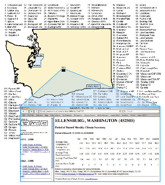
Figure 4.1 — Average monthly temperatures and precipitation can be obtained from internet sources such as the Western Regional Climate Center http://www.wrcc.dri.edu. The data from these stations can be extrapolated to the project site.
4.3.3 Soils
Many counties in the United States have soils maps either completed or in the process of completion. These maps have been developed by the NRCS, and are available at the website http://soils.usda.gov/. This website contains over 200 soil surveys covering large portions of the western United States. If a soil survey is available for the project site, all soils maps covering the road construction area should be printed. Most soil survey websites will have the option to place a topographic map or orthographic photo as a base to a soils map (Figure 4.2B). Soils maps are a composite of soil mapping units with a number or letter within each unit. These alphanumeric codes correspond to a mapping unit narrative that can be found in the text associated with the survey. Locate the narrative for each of the mapping units transected by the road project. The narratives describe a typical soil profile, list the native vegetation, define the land uses for the soil, and summarize soil characteristics, such as water-holding capacity, permeability rates, pH, and soil depth. Most lands administered by the USDA Forest Service will have separate soils reports in addition to, or in lieu of, the NRCS soils report. These reports are often referred to as a Soil Resource Inventory (SRI) report, and can be obtained at the Forest Service district office.
4.3.4 Site Survey
While information from published surveys, maps, or resource inventories is useful, it often does not provide the detail needed for defining and mapping revegetation units. A detailed survey of the project area will verify that preliminary revegetation unit mapping matches the realities in the field. A site survey is usually carried out after the preliminary road location has been staked on the ground. The road location stakes are useful points for collecting site information because they have been surveyed and located on a preliminary road plan, and can therefore be easily referenced throughout the life of the project.
Your site survey should locate, verify, and refine the boundaries of the revegetation units on the ground. Walking the site with maps in hand is key to accurately defining revegetation units. When several resource specialists are involved in collecting site information, they should integrate their survey information to delineate the revegetation units.
After completing your walk-through, it is important to sit down with the highway project maps, pre-field, and field information. As you examine the information collected on soils, climate, and vegetation, the boundaries of revegetation units will probably seem clear. Areas with similar soils, climate, microclimates, and plant communities will be one unit. Management considerations may require that ecologically homogenous units be divided into several units if there are different management goals. Revegetation units should now be sketched onto your project map.
Roadside ecological zones must also be considered when delineating revegetation units (See Chapter 3). Discussing long term objectives with those responsible for road maintenance and engaging in field surveys will help define these zones. Understanding the zones and their corresponding vegetation is necessary to define revegetation units and set appropriate DFCs aligned with road management practices. Otherwise, you may be attempting to establish species that have no chance to survive due to roadside management practices, or you may underinvest in potential plant communities further out from the road margin that are important for healthier roadside ecology.
4.4 Step Three — Locate and Describe Reference Sites
Reference sites provide a reference, or natural model, for possible vegetation outcomes and are important for defining DFCs, as well as later monitoring and evaluation of the project following implementation (SER 2004).
Each revegetation unit should have at least one corresponding reference site that models some aspect of the DFC. The reference site shows how a revegetation unit might recover from disturbances at different points in time after road construction. Reference sites can be considered as a snapshot, or series of snapshots, of possible future outcomes. They demonstrate a point in time along a desirable developmental trajectory of a plant community. Using reference sites to understand the possible vegetative outcomes after disturbances will help the revegetation specialist develop realistic expectations and provide a guide to the development of appropriate revegetation strategies. The revegetation specialist may sometimes choose to obtain baseline ecological data from several reference sites and then assemble DFCs from multiple references (SER 2004).
4.4.1 Disturbed and Undisturbed Reference Sites
Reference sites have similar site characteristics to the corresponding revegetation unit, but are in different stages of plant succession. There are two types of reference sites: disturbed and undisturbed. For most road projects, suitable reference sites will be areas that are ecologically similar to the revegetation unit and have recovered from disturbances similar to those planned in the road construction project. Undisturbed reference sites may also be utilized when ecological restoration is an objective, or when suitable recovered reference sites are not available.
Figure 4.2 — Developing the Revegetation Map.
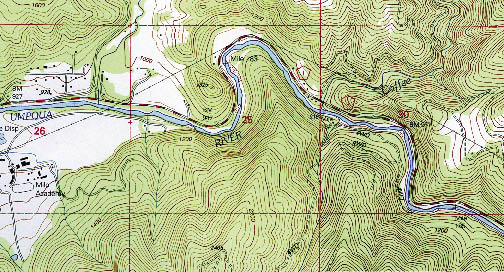
Figure 4.2A — The initial step in developing a revegetation map is to obtain topographic maps of the project area. These maps will then be overlaid with maps for soil, vegetation, ownership, and other relevant information.
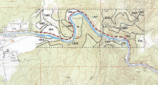
Figure 4.2B — Soils maps are available for most project sites if a soil survey has been completed for the county. Soils maps can be obtained from sources such as the U.S. Department of Agriculture http://soils.usda.gov/, or from contacting a NRCS office. The codes are described in an accompanying soil survey report.
Disturbed reference sites can be categorized several ways:
- Type of disturbance;
- Length of time after the disturbance; and
- Desirability of the recovered vegetation.
Disturbed reference sites can be old road cuts and fills, abandoned roads, ground-based logging sites, waste areas, rock source sites, ski runs, or other areas that have recovered from past disturbances. Disturbed reference sites often show a range of possible vegetative outcomes years after disturbance. Some sites will show good recovery, including stable soil, visually pleasing, and populated by functioning communities of native plants. Others might show what can go wrong if revegetation is not carried out properly, including erosion, poor ground cover, weed infestation, and a lack of native vegetation. Understanding the conditions that lead to these vegetative outcomes can be a guide to avoiding this outcome in the future.
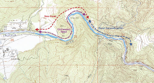
Figure 4.2C — In this example, a portion of an existing road will be reconstructed; a new road section will be constructed through a forested area; and the section of road that is not needed will be obliterated and revegetated.
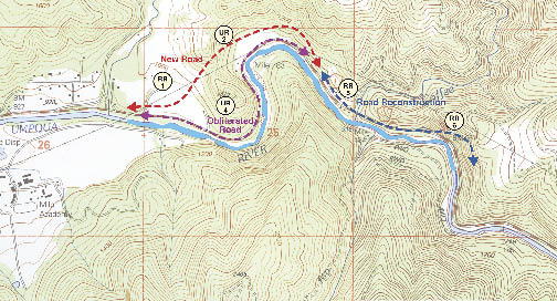
Figure 4.2D — The proposed road location was surveyed on the ground by specialists in soils and botany. The survey identified old disturbances that had revegetated naturally over the last 50 years to a community of native grasses and forbs. Several disturbed reference sites (RR1, RR5 and RR6) were identified. Intensive soil and vegetation surveys were conducted at each site. For the new stretch of forest road, undisturbed reference sites (UR2 and UR4) were identified and surveyed.
Disturbed reference sites are the best models to demonstrate what is possible on the site, what trajectories succession might take (with or possibly without human intervention), and ways to effectively intervene in order to facilitate desired outcomes. Disturbed reference sites are invaluable in developing realistic DFCs. Ideally, the type of disturbance on a disturbed site should match the type of road construction disturbance that will take place on the revegetation unit. For example, if the road cut after construction will be denuded of topsoil, then a disturbed reference site should be found that lacks topsoil.
The stage of recovery is also important. It is ideal to find several disturbed reference sites that represent different successional stages of site recovery. For instance, a revegetation unit would ideally be represented by a recently disturbed site (several years after disturbance), a recently recovered site (5 to 25 years after disturbance), and a fully recovered site (over 25 years since disturbance).
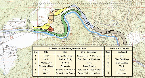
Figure 4.2E — Based on the soil and vegetation data collected during these surveys, six revegetation units were identified (colored areas). The criteria for differentiating these units and their treatments is described in the table below.
While there is no such thing as a "pristine" plant community, an "undisturbed" reference site is an area that has not been heavily impacted by ground-disturbing activities. Undisturbed reference sites indicate the highest potential of a revegetation unit, and are most often used as models when the goal is not merely revegetation, but ecological restoration. The description of soil, climate, and vegetation in an undisturbed reference area can become the framework for the DFC. It provides the revegetation specialist an understanding of those site characteristics or components necessary for healthy ecological functioning.
4.4.2 Locate Reference Sites
The process of selecting and describing reference sites is best accomplished in an interdisciplinary manner. Soils and vegetation specialists should work together to locate, select, and assess reference sites. The discussions that are generated during this process are generally far more thorough in knowledge and understanding of recovery processes than if surveys were conducted separately.
Prior to going to the field to locate reference sites, a list should be made of all reference sites (age, prior disturbance, and desirability) needed for the analysis. Then, using road, soils, and vegetation maps of the area, possible locations for reference sites can be determined. Based on these maps, a "windshield survey" can be conducted by driving adjacent or connecting roads where potential reference sites might be found. Frequently stopping to get out of the vehicle and examine the site will ensure the sites are similar to the general characteristics of the revegetation unit. A search should be done for different ages and plant communities on undisturbed and recovered reference sites. The reference site process will reveal the variation in the project area and will help you understand the best strategy for future surveys. Once reference sites are selected in the field, they are identified on a revegetation map to be surveyed.
Table 4.4 — Reference Sites Should Assessed with a Series of Surveys of Increasing Complexity. |
|||
What |
Where |
How |
Why |
Prefield survey |
Office |
Maps, contacts, literature |
Begin to identify species, communities, and successional processes; determine scope of other surveys |
"Windshield" |
Proposed Road Corridor, existing road and reference sites |
Windshield/drive through |
Get oriented; strategize field survey |
Field Survey |
Proposed road corridor, existing road and reference sites |
Intuitive survey, observe, identify, list |
Develop comprehensive species list, conduct soil survey, define plant communities and successional processes |
4.4.3 Survey Reference Sites
Conducting a series of surveys (Table 4.4) will provide baseline ecological data and a vegetation inventory. The goal is to obtain sufficient information from reference sites to realistically define DFCs. During an initial survey, the appropriate survey intensity can be determined based on information needs and knowledge gaps. For example, if one of the revegetation objectives is to restore an abandoned road to a DFC similar to a neighboring forest, then a survey of vegetation and soils of an undisturbed and disturbed neighboring forest would be conducted to describe the site characteristics and species composition.
Prior to field surveying of reference sites, the data used to define revegetation units (See Section 4.3) should be reviewed. Information regarding land ownership, site history, resources, and past and current management is also valuable. Government specialists who might have knowledge of the soils, vegetation, climate, and hydrology, as well as locals who can provide insight on site history, should be contacted.
Your survey of reference sites should have 4 objectives:
- Create a comprehensive species list,
- Define the plant communities,
- Determine possible successional trends in the plant communities, and
- Survey soils.
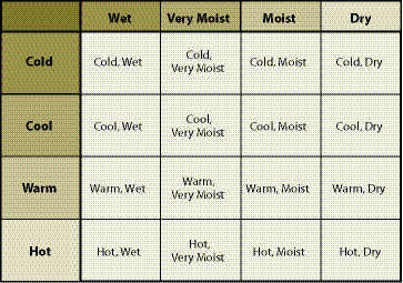
Table 4.5 — Ecological settings in forested sites of the Blue Mountains of northeastern Oregon (Powell and others 1998).
4.4.3.1 Create a Comprehensive Species List
A good method for compiling a comprehensive species list is to choose a representative cross-section of the major habitats and topographical features, with the goal of identifying as many species as possible. This is accomplished by surveying only in areas of maximum diversity. This is sometimes called an "intuitively controlled survey" (Riley 2006). The intuitively controlled survey is appropriate for reference site descriptions because the method maximizes an understanding of species diversity. It should be noted that if there are a few species that cannot be identified in the field, samples should be collected in a plant press and brought back to the office for identification. If more detailed data collection is desired, transects or grids may be run to conduct a vegetation survey.
All observations during or immediately following field surveys should be documented. Note if the species are native or introduced and keep track of species by general life form, including: trees, shrubs, annual grasses, perennial grasses, annual forbs, perennial forbs, sedges, and rushes. This information will be used later in Phase Three to develop a comprehensive species list for the project.
4.4.3.2 Describe Plant Communities
Species should be grouped by plant community and ecological setting. Ecological settings are based on characteristics of the site, which are usually a range of temperature/moisture conditions (Table 4.5).
Within each of these ecological settings, note each plant's amplitude, or how often the species occurs across different ecological settings. For example, a species that crosses eight ecological settings and is found in cold, wet through warm, dry environments would have a wide amplitude. Amplitude is usually quantified in terms of abundance (e.g., stems per square foot), density (ground or canopy cover percentages), or other measures within a given ecological setting. See Phase Three for a detailed description of this process.
Next, note groups of species that commonly occur together within or across ecological settings. The goal of most projects is to revegetate not just individual species, but to develop healthy, functional communities of plants. Gather information that shows how each species fits into an assemblage or association of plants. These assemblages may be referred to as "plant associations," "plant communities," or "guilds." In this manual, the term "plant community" will be used.
One method to define plant communities and successional processes is to refer to agency-created guides, such as a Plant Association Guide or equivalent. (A Plant Association Guide is available for each National Forest.) Based on species lists, density, canopy cover, and/or relative abundance, the Plant Association Guide allows you to key out the plant community in which you are working. The guide also supplies information on associated soil types, full species lists, climate ranges, and how each plant community might respond to different types of disturbances. (For some roadside environments, it may be difficult to identify plant communities because species close to the road can consist of many non-native species.) Patterns of plant communities, their species, and their ages should be noted on a map.
Figure 4.3 — Successional processes and plant communities vary considerably based on site conditions. In this example, plant communities developed differently on north-facing and south-facing slopes.
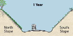
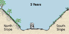
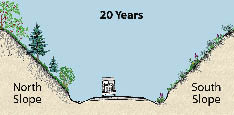
Visiting reference sites and adjacent areas of different seral stages following a disturbance is invaluable in understanding successional processes and guiding revegetation efforts. Characterizing the plant successional stages of the reference sites will be helpful. Categorize the plant communities into four categories: early, mid, and late seral, and climax. Figure 4.3 illustrates how plant communities develop differently over time, depending on site conditions and successional processes.
4.4.3.3 Survey Soils
Understanding the soil characteristics on reference sites is essential to effectively define DFCs. Although soils reports provide general information on soil characteristics, such as soil depth, pH, and water-holding capacity, intensive soil surveys should be conducted on all reference sites. Soil pits should be dug at each site and the following information collected for topsoil and subsoil:
- Soil texture (See Section 5.3),
- Rock fragments (See Section 5.3),
- Rooting depth (See Section 5.3),
- Topsoil depth (See Section 5.5),
- Nutrient levels (See Section 5.5),
- Soil structure (See Section 5.3),
- Litter and duff layers (See Section 5.4),
- Site organic matter (See Section 5.5), and
- Infiltration rates (See Section 5.2).
The process for collecting and interpreting this information is described in depth in Chapter 5 (Planning Phase Two).
4.4.4 Describe Revegetation Units Using Survey Information
The process of describing revegetation units in detail is interpretive and predictive, rather than purely descriptive. You are attempting to define the processes and species in a revegetation unit, using the snapshots obtained from the reference sites. Since each revegetation unit can have several reference sites, the data from these sites must be compiled, summarized, and interpreted. The following questions can help in understanding the ecological processes for revegetation of the site based on reference site information:
- What is the generalized site (soil, climate, vegetation) description of each revegetation unit?
- What are the ecological differences between revegetation units?
- How will each revegetation unit respond to different types of disturbances immediately after construction, in one year, three years, and ten years?
- What are the ecological trajectories for each unit and what are the dominating factors controlling them?
- What are the limiting factors (discussed in detail in the next chapter)?
The answers to these questions should be summarized as an ecological description for each revegetation unit.
4.5 Step Four — Define Desired Future Conditions (DFCs)
Once revegetation units and corresponding reference sites have been identified, mapped, and described, the desired future condition (DFC) can be defined for each unit. The DFC takes the overall revegetation objectives defined earlier and translates them into measurable goals tailored to each management unit. The DFC specifies the desired or expected composition of vegetation at a defined point in time after the completion of the revegetation work.
An example DFC would be, "2 years after seeding, vegetative ground cover will be 50%; of this cover, 75% will be composed of perennial native species." Stating expectations in this manner will:
- Clarify how the site will appear after treatments;
- Narrow down the appropriate revegetation treatments; and
- Define measurable criteria, or thresholds, that can be used for monitoring project success.
Commonly stated DFC criteria include:
- Vegetative ground cover (%),
- Bare soil (%),
- Native plant cover (%),
- Seedling survival (%),
- Seedling density (plants per area), and
- Tree growth (height per year).
Stating the DFC in measurable terms and with a timeline ensures that the project team, regulatory agencies, and the public have similar expectations of how the project will unfold. Quantifying the objectives also allows monitoring to determine how well project objectives were met. For example, if one of the objectives is erosion control, a quantifiable criteria for a desired future condition might be, "bare soil one year after road construction will be less than 20%." If another objective is the establishment of native plants, then a measurable threshold for success might be, "native perennial grasses and forbs will occupy over 40% of the site within three years of seeding." How to develop and implement monitoring and adaptive management is described in Chapters 11 and 12.
DFCs are stated within a time frame, which is commonly defined as the number of years after project disturbance. Defining DFCs usually takes into consideration how the revegetation units could look in both short-term (1-3 years) and long-term (5, 10, 15+ year) time frames. Asking a series of questions about the site's potential future condition is an important part of the thought process. What might happen with no intervention or management? What might happen with massive intervention and mitigation? Between these two extremes, what are the key leverage points that might provide for healthy succession of the local plant communities with minimal human intervention after the road is constructed? How could various interventions be timed, from the beginning of the project through infusions of energy and resources a few years after establishment? From an ecological standpoint, what is the optimal future condition for the site in short- and long-term time frames? Given constraints and limitations, what is possible and feasible on the site?
Another key aspect of defining DFCs is refining your understanding of limiting factors regarding the types of native vegetation that you hope to re-establish. In Phase Two, a comprehensive assessment of limiting factors for general revegetation will be carried out. In Phase Three, more information about the local native species and their requirements will be gathered. As species and site information are analyzed, some factors will emerge as more limiting to particular vegetation types than others. For example, water input might be limited on the site. However, if native drought-tolerant species are planted, water will be less of a limitation than if you were using species that require more water.
Revegetation strategies should be developed that will set the trajectory during establishment to arrive where you want the site to be in 10 years. Site parameters that might limit long-term, not just short term, plant establishment must also be considered. When developing DFCs, think in terms of the plant succession that is likely to occur on each revegetation unit. In some cases, planting early seral species at the outset may work. By year 3, when the early seral species begin to decline, the late seral species may be increasing. In other cases, you may need to intervene several years after the early establishment phase of the project in order to support healthy succession. For example, short-term revegetation planning might call for seeding grasses and forbs to stabilize the site. One year later, the site might be revisited to remove any invasive species before they produce seeds. Two years later, the site might be revisited to interplant conifers and shrubs to meet long-term objectives. These three intervention points (seeding, weeding, and planting trees) speed succession in order to establish a sustainable plant community on the site.
4.6 Next Steps
With the revegetation units defined, reference sites described, and desired future conditions drafted, Phase One is complete and you are ready to move on to the next phases of the planning process. You will have more chances to reexamine and refine the DFCs in subsequent phases. For now, you can make an informed attempt at setting the DFCs for each revegetation unit, including specifying time and place. In Phase Two, the site attributes critical for plant establishment and long-term plant community development are described for each revegetation unit. The assessment of soils and climate made during the survey of reference sites should reveal if site characteristics are either obstacles to, or resources for, achieving DFCs. Based on the determination of limiting factors, a menu of the possible mitigating measures is developed. Once the limiting factors are understood, the vegetation is analyzed in greater depth in Phase Three. From the comprehensive list of species and plant communities present on the site, you will determine which species and groups are best adapted to the site and best suited to revegetation needs. Options for stocktypes and application methods are considered in order to achieve the best results. Finally, in Phase Four, all the elements are pulled together, selections are made, and recommendations are compiled into a comprehensive strategy and timeline for site treatments and revegetation strategies, or the Revegetation Plan.