ROADSIDE REVEGETATION
An Integrated Approach to Establishing Native Plants and Pollinator Habitat
Learn
Rainfall Simulation Trials
| Location: | Sunriver Interchange (intersection of Highway 97 and South Century Drive) and Sunriver to Bachelor Highway (Highway 45) |
| Lat/Long: | N43o58'26.04", W121o36'38.7" and N43o52'11.1", W121o24'6.3" |
| Dates Implemented: | July 2006 |
| Client: | Western Federal Lands Highway Division |
| Planners: | R6 Restoration Services Team, Michael Hogan |
| Contractors: | Integrated Environmental Restoration Services, Inc. |
| Case Number: | 0007 |
| Date Submitted: | December 2008 |
| Focus Area: | Soil Improvement, Erosion Control, Soil Imprinting |
Background and Objectives
At the time this project was implemented, the R6 Restoration Services Team was working on three roadside projects south of Bend Oregon - Sunriver Interchange, Sunriver to Bachelor, and South Century Highways. The limiting factors facing the revegetation of disturbed roadsides in this area are attributed to the low annual precipitation rates (<12") and the low humidity. Soils are composed of deep loamy sands and sandy loams derived from volcanic ash. These textures do not have high water holding capacities, which makes establishment of vegetation difficult nevertheless, the deep soils and low rock fragments make these site relatively productive once vegetation has become established. In locating reference sites for these projects, we found roadsides along Highway 97 where they were barren. We learned that these sites were highly compacted and because of this, roots were not able to access the moisture deeper in the soil profile. A complicating factor is that infiltration rates are low on compacted soils, resulting in high runoff and erosion, which limit the establishment of vegetation from seed.
Based on these findings, it was important to understand what practices could be taken to reduce the effects of compaction during or after construction. A small study, using a rainfall simulator and soil penetrometer was installed to evaluate the effects of several conservation practices available to the road construction engineer on soil properties. The rainfall simulator quantifies the infiltration rates, sediment delivery rates, and runoff rates, important factors for plant establishment and water quality, while the cone penetrometer measures the depth to compaction. The objective of the rainfall simulation study was to compare the infiltration, sediment delivery, and runoff rates of four road construction practices: 1) trackwalking with bare soil (TW), 2) trackwalking with 0.8 inches of wood mulch (TWM), 3) bucket imprinting (BI), and 4) clearing and grubbing only (GC).
Implementation
The "midget" rainfall simulator that was used in this study is a portable simulator, designed for steep slopes and field conditions. It creates raindrops through a system of syringe needles under equal pressure. Raindrops fall from a 1 meter height into a 0.8 meter by 0.8 meter plot frame. Runoff is collected at the bottom of the plots to calculate infiltration rates, runoff rates, and sediment yield. Three rainfall plots were installed for each treatment. In addition, depth to compaction measurements were made with a cone penetrometer.
At the time we began this project, trackwalking (TW) was occurring on the finished cutslopes at the Sunriver Interchange. Rainfall simulation plots were installed on these slopes as well as trackwalked slopes that had been covered by an 0.8 mulch cover of wood fiber (TWM). Nearby, where new road clearing work was taking place, we established plots on sites where the vegetation and roots had been removed but soils had not been compacted (GC). The last plots were established on the Sunriver to Bachelor Highway project, several miles away, where the conservation practice of bucket imprinting (BI) was being applied to the finished slopes. In this practice the bucket of an excavator (with several pieces of rebar welded vertically to the bucket) creates surface roughness similar to trackwalking but with far less compaction.
Findings
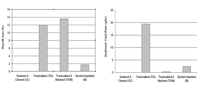
Runoff rates were high for trackwalked soils even with a mulch cover. Bucket imprinted soils had relatively low runoff rates and grubbed and cleared soils had no runoff after 45 minutes. Sediment yields were also very high for bare trackwalked slopes however, when trackwalked soils were covered with mulch, the sediment yields were significantly reduced. Trackwalking appears to reduce infiltration rates, increase runoff, and increase sediment yields, as compared to practices that do not compact the soils as much.
Figures
The graph on the left shows the runoff rates of each treatment using the rainfall simulator and the graph on the right shows the sediment yield rates.
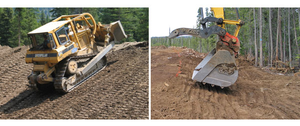
The picture on the left shows trackwalking and the picture on the right shows bucket imprinting. While the surfaces appear similar, the compressive forces are far less with bucket imprinting.
Applicability
The findings from this trial can be applied to soils derived from volcanic ash in semi-arid climates. By utilizing construction practices that minimize soil compaction, precipitation is not lost to runoff, but enters the soil and is available to the roots of developing plant communities. In semi arid environments, where soil moisture is at a premium, this additional soil moisture could determine whether plants will survive or not. In addition, the high soil strengths (measured with the cone penetrometer) and poor infiltration rates indicate that root penetration in compacted pumice soils is very difficult, reducing the volume of soil (and soil moisture) accessible to the plant during the growing season.
Related Links
Executive Summary Simulated Rainfall Evaluation at Sunriver and Mt Bachelor Highways, Oregon (1.53 MB PDF)
Erosion
Control Reduces Fine Particles in Runoff to Lake Tahoe (712
KB PDF)
Contact Information
David Steinfeld, USDA Forest Service; 541-552-2912, dsteinfeld@fs.fed.us