ROADSIDE REVEGETATION
An Integrated Approach to Establishing Native Plants and Pollinator Habitat

3.5 Identifying Reference Sites
Reference sites provide a natural model for possible vegetation outcomes and are important for defining DFC targets, as well as evaluating and monitoring the project following implementation (SER 2004). They can also be used to document the types and amounts of pollinator species that may be present in putatively natural environments near the project area.
Each revegetation unit should have at least one corresponding reference site that models the expected outcome or DFC target of the unit. Ideally the reference site shows how a revegetation unit might recover from disturbances at different points in time after road construction. Reference sites can be considered a snapshot, or series of snapshots, of possible future outcomes. They demonstrate a point in time along a desirable developmental trajectory for a plant community. Using reference sites to understand the possible vegetative outcomes after disturbances will help the designer develop realistic expectations and provide a guide to the development of appropriate revegetation strategies for each revegetation unit. The most important aspect of reference sites is that they provide examples of plant communities from which designers can chose individual species for use in the revegetation project. The designer may sometimes choose to obtain baseline ecological data from several reference sites and then assemble DFC targets (SER 2004).
The two types of reference sites are disturbed and undisturbed. Disturbed reference sites are areas, typically old road cuts and road fills that have recovered, whereas undisturbed reference sites are relatively pristine sites that lack major disturbances in the recent past. For most road projects, disturbed reference sites are the most helpful because they represent sites that are ecologically similar to the revegetation unit and have recovered from disturbances similar to those planned. Undisturbed reference sites may also be used when ecological restoration is an objective or when suitable disturbed reference sites are not available.
Disturbed reference sites can be categorized several ways:
- Type of disturbance
- Length of time after the disturbance
- Desirability of the recovered vegetation
Disturbed reference sites can be old road cuts and fills, abandoned roads, ground-based logging sites, waste areas, rock source sites, ski runs, or other areas that have recovered from major soil disturbances. Disturbed reference sites often show a range of possible vegetative outcomes years after disturbance. Some sites will show good recovery and include stable soil, be visually pleasing, and populated by functioning communities of native plants. Others might show what can go wrong if revegetation is not carried out properly, including erosion, poor ground cover, weed infestation, and a lack of native vegetation. Understanding the conditions that lead to these vegetative outcomes can be a guide to avoiding them in the future.
Disturbed reference sites are the best models to demonstrate what is possible on the site in terms of vegetation, what trajectories succession might take (with or possibly without human intervention), and ways to effectively intervene in order to facilitate desired outcomes. Disturbed reference sites are invaluable in developing realistic DFC targets. Ideally, the type of disturbance on a disturbed site should match the type of road construction disturbance that will occur on the revegetation unit. For example, if the road cut after construction will be denuded of topsoil, then a disturbed reference site should be found that lacks topsoil.
The stage of recovery is also important. It is ideal to find several disturbed reference sites that represent different successional stages of site recovery (Figure 3-9). For instance, a revegetation unit would ideally be represented by a recently disturbed site (several years after disturbance), a recently recovered site (5 to 25 years after disturbance), and a fully recovered site (over 25 years since disturbance).
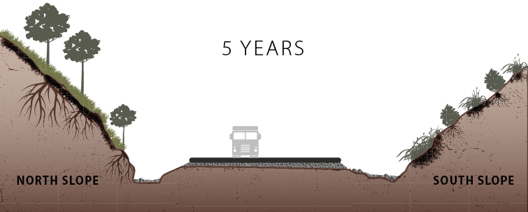
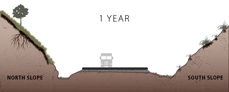
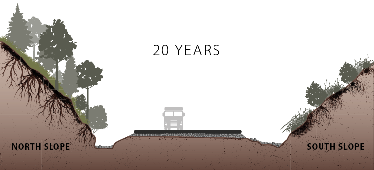
Figure 3-9 | Successional processes vary by microsite
Successional processes and plant communities vary considerably based on microsite conditions. In this example, plant communities developed differently on north-facing and south-facing slopes.
While there is no such thing as a "pristine" plant community, an "undisturbed" reference site is an area that has not been heavily affected by ground-disturbing activities. Undisturbed reference sites indicate the highest potential of a revegetation unit and are most often used as models when the goal is ecological restoration (re-creation of a plant community identical to that which existed before disturbance). The description of soil, climate, and vegetation in an undisturbed reference area often become the framework for the DFC target. It provides the designer with an understanding of those site characteristics or components necessary for healthy ecological functioning.
The process of selecting and describing reference sites is best accomplished in an interdisciplinary manner. The discussions that are generated between soils and vegetation specialists are generally far more thorough in knowledge and understanding of recovery processes than if surveys were conducted separately. Disturbed reference sites can be located by driving the roads in and around the project area and finding areas that appear similar to the type of road construction being planned for a revegetation unit. Revegetated road cuts of various ages are good reference sites for cut slope revegetation units.